Geolocating tool
In Wikidocumentaries all openly licensed images can be geotagged. This is not available for images, whose reuse is restricted.
Images can be geolocated with the desktop geolocating tool (this), and the images can also be rephotographed and geotagged with the Ajapaik mobile app (to be configured later).
Contents
Accessing the geolocating tool
Access to geotagging is available with each image in the images module on the topic page and the image image viewer.


Action
@/components/menu/ActionMenuImages.vue
MENU_ACTIONS.DO_GEOLOCATING
Properties added to the image item
The most essential metadata of an image is saved into Wikidocumentaries on the moment it is selected for enriching. Any action in the actions menu will make this happen.
The workflow
The geotagging interface is based on the Wikidocumentaries tool page layout. It includes a split view of the image and the zoomable map.
Step 1: Find the main subject
Step 2.1: Found item, topic has coordinates
Step 2.1.1: Modify pin location
Step 2.2: Found item, topic without coordinates
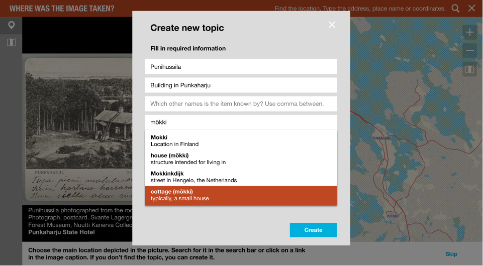
Step 3: Create new topic
Step 4: Set camera angle


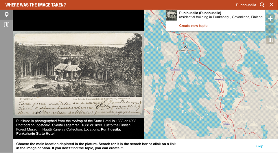
Step 1: Find the main subject
Choose an existing location with the search pulldown (data from Wikidata and Wikidocumentaries).
- Pin: NO pin
- Prompt: "What is the main location depicted in the picture? Search for the topic in the top bar search field."
- Step indicator: POI
- Buttons: Skip
- Pulldown: Found item, Create new topic
- Links in the caption = Found item
- Found item
- Found item, topic has coordinates > Step 2.1
- Found item, topic without coordinates > Step 2.2
- Create new topic > Step 3
- Skip > Step 4
- Found item
Step 2: Found item
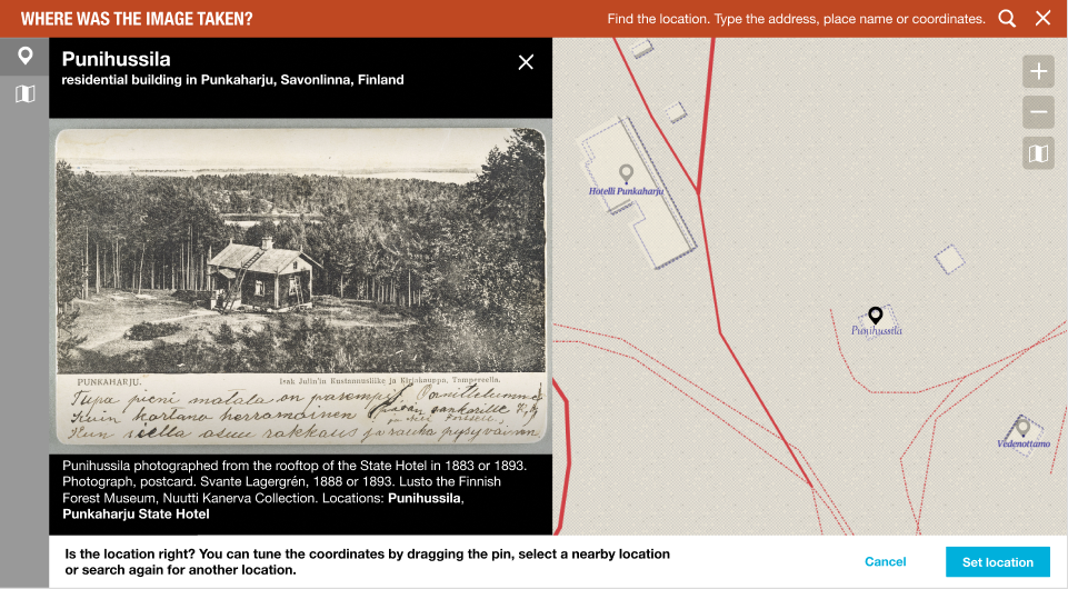
Step 2.1: Found item, topic has coordinates
- Pin: BLACK pin on the item
- Prompt: "Is the location right? You can tune the coordinates by dragging the pin or search again for another location."
- Step indicator: POI
- Item title on top of the image + Button (cross) Remove item (only if you have selected an item.)
- Buttons: Set location
- Move the pin > Step 2.1.1
- Set location
- Save value Wikidata location item ID to property depicts Wikidata item (P5129) in the image item in Wikidocumentaries
- > Step 4
- Button (cross) > Step 1
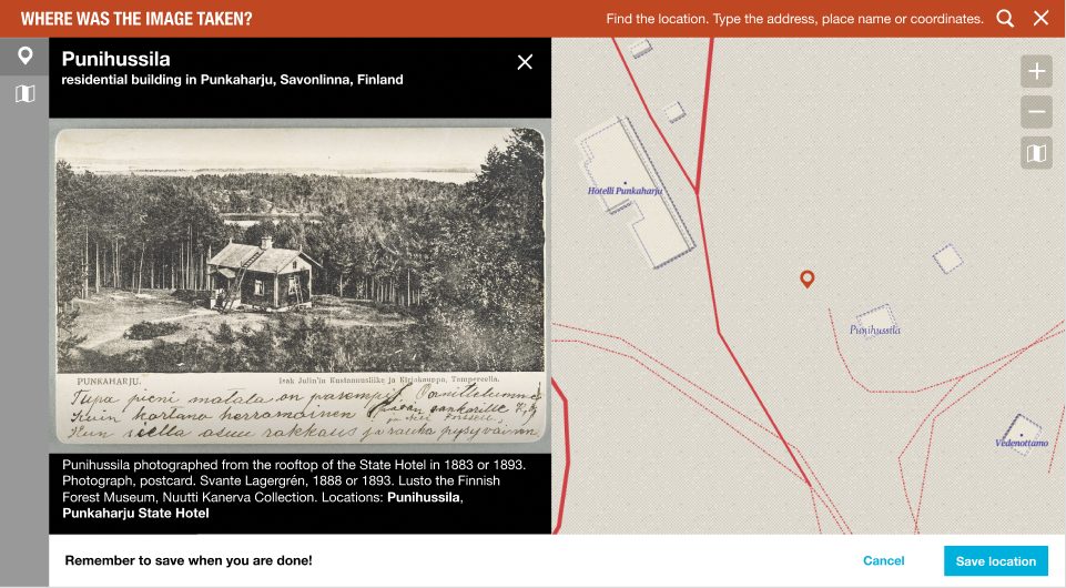
Step 2.1.1: Modify pin location
- Pin: RED pin
- Prompt: "Remember to save when you are done!"
- Step indicator: POI
- Buttons: Save location, Cancel
- Save location
- Save value target coordinates to property coordinate location (P625) to the Wikidata location item in Wikidata
- Save value Wikidata location item ID to property depicts Wikidata item (P5129) in the image item in Wikidocumentaries
- > Step 4
- Cancel > Step 2.1
- Save location
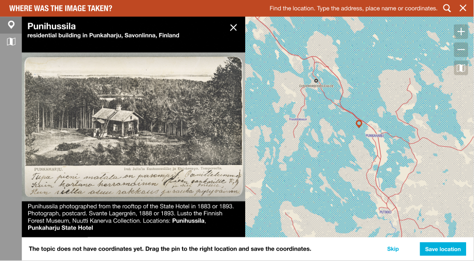
Step 2.2: Found item, topic without coordinates
- Pin: RED pin in the middle of the map window
- Prompt: "The topic does not have coordinates yet. Drag the pin to the right location and save the coordinates."
- Step indicator: POI
- Item title on top of the image + Button (cross) Remove item
- Buttons: Save location, Skip
- Save location
- Save value target coordinates to property coordinate location (P625) to the Wikidata location item in Wikidata
- > Step 4
- Skip > Step 4
- Button (cross) > Step 1
- Save location
Step 3: Create new topic
- Modal: Create new topic modal (label, description, aliases, instance of -pulldown)
- Modal buttons: Create, Cancel
- Create
- Create new item in Wikidata
- Add label, description, aliases, instance of P31
- > Step 2.2
- Cancel > Step 1
- Create
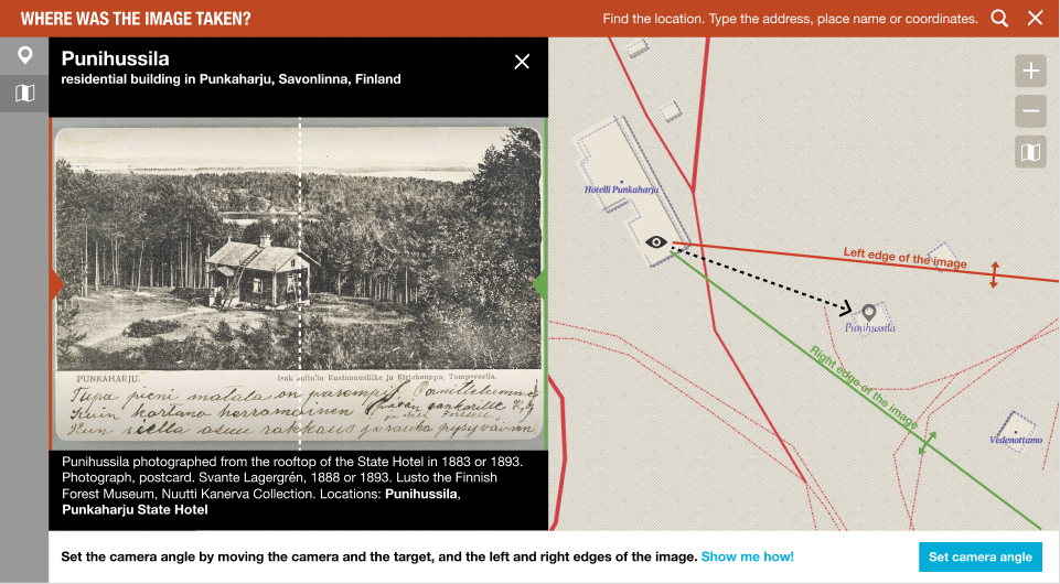
Step 4: Set camera angle
- Pin: 50% BLACK pin (if attached to a topic)
- Handles: Camera/eye, left edge, right edge, target
- Prompt: "Set the camera angle by moving the camera and the target, and the left and right edges of the image. Show me how!"
- Step indicator: Map
- Item title on top of the image + Button (cross) Remove item
- Buttons: Set camera angle
- Show me how > Step 4.1
- Set camera angle
- Save data to the Wikidocumentaries image item
- coordinates of the point of view (P247), camera heading (P5127), field of view (P2984)
- User ID of the submitter. How?
- Date stamp
- > Step 5
- Save data to the Wikidocumentaries image item
- Button (cross)
- Remove the location item id from the depicts Wikidata item (P5129) property in the image item in Wikidocumentaries
- > Step 4
Step 4.1: Show me how modal
Illustration/animation to explain the camera angle thingy
- Modal: Title
- Modal buttons: OK!
- OK > Step 4.
Step 5: Yay!
- Display a 3D view for example?
- Want to locate another picture?
- Want to do something else to this image? Annotate: Identify more places or people? Set the date?
Controls
- Select background imagery
- The base map (different styles?)
- General map: In Finland the National Land Survey map
- Aerial image: In Finland the National Land Survey aerial imagery
- Map layers
- MapWarper
Storing geotagging data
The geotagging data is added to the local image metadata. See Metadata mapping for details.
Seek to the right location
- The map could seek to a suggested location by parsing the data in the name and description, or existing location information in the image metadata.
- The location links in the image metadata could set the location similarly to actions in the workflow.
Enhancement ideas
Mirror the image
- It may be useful to be able to mirror the image. Would geolocating be a good place for that. Perhaps yes. At what stage?
Adjust left and right edges of the image on the image
Display surrounding items
- The user could see items surrounding the found item and change the target by selecting the pin.
Items in the field of view
- The POIs in the field of view on the map would also be displayed as vertical lines on the image. The user could drag the lines to right locations, and the camera position on the map would be corrected accordingly.
Annotate while geolocating
- A tool in the top bar perhaps to make quick annotations of "depicts". Could be POIs but rather rectangles or even trapezoids. Could be considered together with IIIF.
- The user could frame the side of a building in the image (or other object: street, pond, statue...) and locate the equivalent on the map. This could give an estimation of the photographer's position.
3D-editing
- After setting the camera position and the target on the map, the user could fine tune the values in perspective mode:
- Image and map overlaid
- Change the elevation of the image target and the photographer position. Calculate pitch.
3D viewing
- Elaborating the idea by Matthias Müller-Prove. (Will add a screenshot)
- In step 5 the user could see the image placed on the map in 3D
Crowdsourcing workflows.
- We can also contribute to a standardised exchange format for geotagged photos.
Importing to Wikimedia Commons
- The original image, the image metadata and the added geolocation will be imported to Wikimedia Commons either manually immediately or as a scheduled bot task later.
- Task: Ensure equivalent properties in SDC.
- The original memory institution will be able to read the enhanced data from Wikimedia Commons.
- Task: Investigate best practises.
Inspiration
Ajapaik web app


| About | Technology | Design | Content modules | Tool pages | Projects |
| Status
Wikidocumentaries Slack |
Setting up dev environment |
Components |
Active modules Module ideas |
Visual editor | Central Park Archives |